California faces persistent flooding over the weekend after rounds of deadly storms
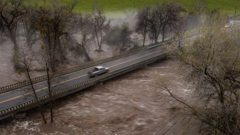
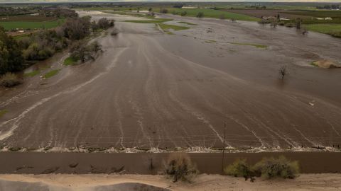
CNN — Forceful flooding that washed away roads and sent residents across parts of northern and central California fleeing their homes is expected to continue Saturday and through the weekend as more rain arrives.
But Saturday is not projected to bring the torrential walls of rain that battered communities Friday, which saw bridges collapse, roads split open and caused thousands of power outages.
At least two people have died as a result of the storms, officials said.
“Overall the environmental ingredients aren’t as impressive as the recent strong atmospheric river event, but nonetheless a prolonged period of light to occasionally moderate rainfall is expected across parts of central to northern California” on Saturday, the Weather Prediction Center said.
The impacts from this week’s storms have been compounded after severe rainfall was dumped over the same areas buried by heavy snowfalls the past two weeks. Melting snowpack will play a role in prolonging flooding over the upcoming days, forecasters have said.
About 15 million people were under flood watches – stretching from as far north as Redding southward to San Bernardino in California, and included parts of northwest Nevada. Flood warnings were still in effect across portions of northern and central California through early Saturday.

A slight risk of excessive rainfall, a level 2 out of 4, has also been issued across portions of the northern California coast as well as down the western foothills of the Sierra Nevada. Widespread rainfall totals of 1 to 3 inches are expected Saturday.
Evacuations orders were expanded in Tulare County to include the community of Teviston as well as parts of Cutler and Exeter because river flow had increased, according to the county sheriff’s office Friday night. Officials urged residents to stay clear of waterways and avoid all unnecessary travel.
“Due to the amount of added water to Lake Success from the rain and runoff, the water levels are predicted to reach the spillway,” the sheriff’s office said.
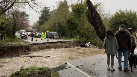
Friday’s heavy rains pummeled Santa Cruz County, where about 700 residents in Soquel became trapped after a pipe failure led to severe flooding and the collapse of the one road linking the community to the rest of the region, according to Steve Wiesner, the county’s assistant public works director. Residents will remain isolated until a new crossing can be created, which could take days, Wiesner said.
“This is the one road that leads into town,” resident Molly Watson told CNN. “We are now an island.”

A photo Watson shared with CNN captures a chaotic scene where a large piece of road is washed out by flood waters while cracked pavement appears to sink into the rushing water. Emergency crews stand on one side of road – on the other, residents look on.
“I’ve lived here my whole life, and I’ve never seen the creek go actually through the road,” Soquel resident Nick Maleta told CNN affiliate KGO, and likened the powerful heavy rainfall to a tornado.
“All night long, you could hear, the water is so saturated right and the cottonwoods especially are so weak, you could just hear them tumbling all night long,” Maleta said.
Soquel is one of the hardest-hit areas in Santa Cruz County, soaking more than 6.5 inches of rain in certain areas while widespread rainfall was about 2 inches, according to a report from the National Weather Service office in San Francisco.
As of Saturday morning, more than 41,000 homes and businesses across the state were without power, with about 30,000 of those outages in coastal Monterey County, according to tracking site PowerOutage.us.
Luis Alejo, chair of the Monterey County board of supervisors, tweeted Saturday that the “worst case scenario” had arrived with the Pajaro River overtopping and a levee breaching around midnight local time.
Sheriff’s deputies were going door-to-door to get remaining residents in affected neighborhoods to leave before water inundated their homes, said county Office of Emergency Services Manager Gerry Malais.
“National Guard high-water rescue vehicles that were requested by the County of Monterey and swift-water rescue team members are also on the scene,” said the county. “Residents in the evacuation zone that need help should call 9-1-1 immediately.”
To alleviate yet another natural disaster gripping California, President Joe Biden approved a state of emergency declaration requested by Gov. Gavin Newsom. The move frees funds for the millions of residents who have been hit with severe weather since the beginning of the year.
Meanwhile, Nevada Gov. Joe Lombardo issued a state of emergency for Churchill, Douglas and Lyon counties in the northern section of the state due to flooding associated with the same storm.
“Severe weather has brought heavy rainfall, flooding, and infrastructure damage to northern Nevada. As severe weather conditions continue, further flooding and infrastructure damage are anticipated throughout the region,” the governor’s office said in a statement.

Parts of California saw more than a foot of rain
An atmospheric river – which consists of long, narrow bands of moisture in the atmosphere that carry warm air and water vapor from the tropics – brought colossal amounts of rain in places that could not bear taking any more.
Anderson Peak in Monterey County was drenched with 13.63 inches of rain, according to the NWS’ San Francisco office. Elsewhere in the county, isolated rainfalls in Hearst Castle were 11.61 inches and 8.36 inches.
Double-digit inches of rain were also seen in San Mateo County’s Pacifica, where 13.41 inches of rainfall were reported. Several areas in Santa Cruz County saw more than 5 inches of rain while 6.56 inches of isolated rainfall were recorded in Sonoma County.
In Tulare County, the sheriff’s office received reports of widespread flooding, collapsed bridges, downed trees and separated roads.
The intense rain came as 34 of California’s 58 counties have been under a state of emergency issued by the governor’s office due to previous storms and this week’s severe weather threat.

Officials release water from major dam
To manage the heavy amounts of rainfall, California water officials have begun releasing water from the main spillway at the Oroville Dam for the first time in four years, according to a news release from the California Department of Water Resources.
The spillway of Oroville Dam, the nation’s tallest dam at 770 feet in the Feather River, opened Friday at noon and are expected to remain through the weekend.
“In anticipation of increased runoff inflows into the reservoir, DWR has begun increasing water releases to the Feather River through the Hyatt Powerplant and from the main spillway. These releases provide flood control protection for downstream communities,” the department said, adding that the tactic is coordinated closely with the US Army Corps of Engineers and other water operators.
In 2017, the dam was closed for two years after powerful storms caused Lake Oroville’s water level to rise and overflow the dam. It reopened in 2019 after crews reconstructed its full functionality.
CNN meteorologists Taylor Ward and Haley Brink and CNN’s Taylor Romine, Rebekah Riess, Cheri Mossburg, Jillian Sykes, Joe Sutton, Sara Smart and Dave Alsup contributed to this report.


