(CNN) — Tropical Storm Melissa is barely moving through the Caribbean, and that’s exactly what makes it so dangerous. The longer it lingers, the more rain it dumps and the more likely it is to rapidly intensify into a monster storm.
Intensity forecasts have ramped up considerably in the past few days. A worst-case scenario for some Caribbean islands is increasingly likely with Melissa set to reach at least Category 4 hurricane strength next week, fueled by extremely warm water.
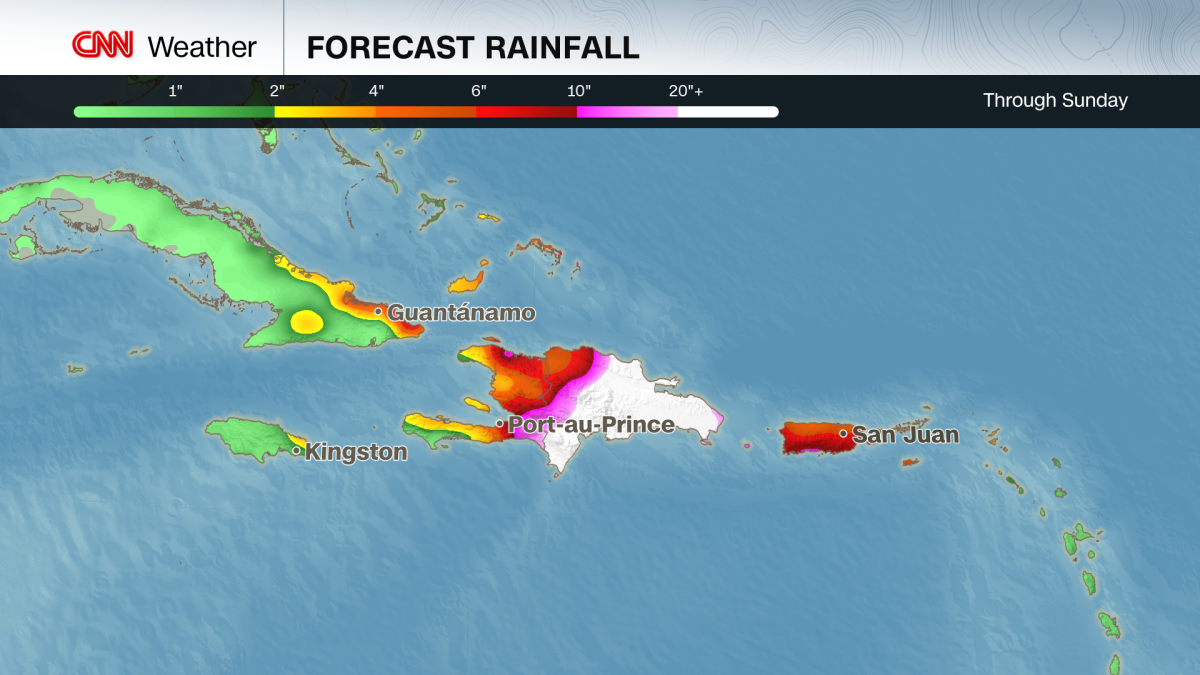
A tropical storm warning is in effect for Jamaica with Melissa’s outermost winds expected to reach there in the next day or so. Hurricane watches are in effect for Jamaica and parts of Haiti, meaning hurricane-force winds are possible by the weekend. Haiti, Jamaica and parts of the Dominican Republic face days of heavy rain that threaten significant flash flooding and dangerous mudslides.
Jamaica could end up being the epicenter of the worst Melissa has to offer, based on current forecasts. Preparations were well underway in the country Thursday as officials urged residents to take Melissa seriously and stay vigilant.
All public hospitals are set to go into “emergency mode” Thursday evening, Christopher Tufton, Jamaica’s Minister of Health and Wellness confirmed at a news conference. This designation halts outpatient and elective procedures and ensures more beds are open for emergencies.
Jamaica’s airports remain open for now, but will likely close within 24 hours of a hurricane warning being issued for the country, according to Daryl Vaz, Minister of Science, Energy, Telecommunications and Transport.
As of Thursday evening, Melissa was about 165 miles south-southeast of Kingston, Jamaica, with sustained winds of 45 mph, according to the National Hurricane Center. It’s drifting north-northwest at just 2 mph, slower than the average person on an afternoon stroll.
Melissa is forecast to reach hurricane strength by the weekend and will likely rapidly intensify into a major hurricane — Category 3 or greater — Monday. This explosive strengthening is happening more often as the world warms due to fossil fuel pollution. Three of the four Atlantic hurricanes this season underwent extreme rapid intensification: Erin, Gabrielle and Humberto.
Melissa is already bringing heavy rain to parts of the Caribbean. Up to 10 inches of rain could fall, with isolated totals topping a foot across southern Haiti, southern Dominican Republic and eastern Jamaica through the weekend. Those totals will likely climb even higher early next week, but by exactly how much depends on Melissa’s track and intensity.
The United States mainland is not completely out of the woods, but a direct hit looks unlikely. If Melissa takes longer to turn north, it could bend toward eastern Cuba or the Bahamas before curving into the Atlantic. Even so, rough surf and rip currents could spread along the US East Coast next week.
There’s also still a slim chance that Melissa takes a sharp turn to the north earlier than expected and bears down directly on Haiti. That scenario would deliver highly-concentrated impacts there and torrential rain to the Dominican Republic.
Why Melissa’s forecast is so alarming
- It’s barely moving. When a storm crawls like this, rainfall piles up over the same towns for days. A similar setup produced catastrophic floods in 2017 with Hurricane Harvey, which dumped over four feet of rain on parts of Texas, and in 2019 with Hurricane Dorian, which dropped nearly two feet of rain in the Bahamas and over a foot in parts of South Carolina.
- Mountains magnify the flood threat. Haiti, Jamaica and the Dominican Republic’s steep terrain will force air upward, wringing out more moisture from the storm, just like squeezing a wet sponge, turning tropical humidity into torrents racing downhill. Mudslides are all but guaranteed in this scenario. This happened when Hurricane Helene devastated western North Carolina last year. Helene was moving more quickly than Melissa, which will pack even more of a punch as it stalls out over similar steep terrain.
- Heat in the Caribbean Sea runs deep. The Caribbean’s exceptionally-warm water extends far below the surface, preventing the usual “stirring up” of cooler water that can weaken hurricanes. Melissa is expected to feast on that deep reservoir of heat, raising the ceiling on its potential intensity.
Melissa’s path and strength will keep evolving in the days ahead, but the warning signs are already there for millions of vulnerable people in the Caribbean.