(CNN) — A round of frigid temperatures is sweeping across much of the United States this week, bringing dangerously cold conditions to millions and setting the stage for widespread disruptions.
This Arctic air will interact with a storm system moving out of the Rockies to create hazardous winter weather across much of the Central US and Ohio Valley. At the same time, the bitter cold will complicate recovery efforts in parts of Kentucky, West Virginia and the mid-Atlantic, where communities are still reeling from a deadly flooding caused by storms over the weekend.
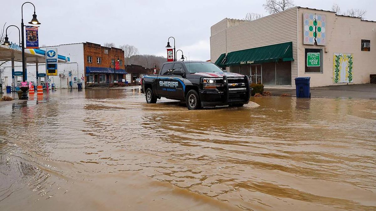
At least 14 people have died in the aftermath of this weekend’s storm, including 12 in Kentucky, where extensive flood damage has left many communities struggling to recover.
Two others appeared to have died from hypothermia in Kentucky’s Jefferson County, Kentucky Gov. Andy Beshear said at a Tuesday morning news conference.
“That should tell all of us the weather conditions are as dangerous as that water is,” Beshear said, referring to the ongoing brutal cold and snow coming to the state.
The cold air will get more intense and expansive throughout the week so that about three-quarters of the US population is expected to experience below-freezing conditions by Friday. Temperatures will plunge as much as 50 degrees below February averages, threatening to break more than 270 temperature records across at least 27 states.
Snow headed for Kentucky in wake of deadly flooding
February has been an incredibly active month for disruptive and deadly winter storms in the US and that hyperactive pattern isn’t over yet.
A new winter storm will dump 3 to 6 inches of snow over much of flooded Kentucky and more than 6 inches in parts of West Virginia. Snow will compound the post-storm cleanup process for Kentucky.
“We’re going to have our … city and county folks still working the flooding and debris removal at the same time that they’re trying to work the snow issues, ” Gov. Andy Beshear said during a Monday news conference. “It’s going to really complicate the cleanup.”
Beshear said the flooding was “one of the most significant natural disasters we’ve seen in our lifetime” and that, though the rain had stopped, the emergency is far from over, as rivers and streams remain dangerously swollen.
“There are individuals out there that still need help, that are still getting in contact with us,” Beshear said after visiting Pike County, one of the hardest-hit areas.
In neighboring Martin County, rising waters forced the evacuation of at least 237 residents by helicopter and boat from two apartment complexes, Beshear confirmed.
Since the flooding began, emergency crews from the Kentucky National Guard and Kentucky State Police have conducted more than 1,000 rescues, Beshear said.
In West Virginia, several people remained missing amid “significant levels of flooding,” Gov. Patrick Morrisey said Monday.
Life-threatening cold expands while new storm strengthens
The coldest air of winter started to work its way into the northern US early this week and will expand rapidly in the coming days.
Wind chill temperatures reached a life-threatening nearly 60 degrees below zero in parts of Montana and North Dakota Tuesday morning. Tuesday was the coldest it’s been in Bismarck, North Dakota, in more than 16 years. Below zero wind chills extended as far south as Oklahoma and the Texas Panhandle.
Overall, more than 75 million people are under cold weather alerts spanning the Plains, Midwest, Great Lakes and Northeast.
Snow was falling in parts of the central US Tuesday morning as a new winter storm started to strengthen. It will bury an area from Kansas and Oklahoma to the central Appalachians and mid-Atlantic in heavy snow and deliver dangerous ice to areas just south.
Parts of Kansas, Oklahoma, Missouri and Arkansas could record more than a foot of snow Tuesday into Wednesday. Springfield, Missouri, could receive a foot of snow — the most in nearly 20 years. Major impacts from the storm are expected in this region, including dangerous to impossible driving conditions, according to NOAA’s Winter Storm Severity Index.
Arkansas Gov. Sarah Huckabee Sanders declared a state of emergency Monday ahead of the storm’s arrival in the state.
Memphis, Tennessee, could record 1 to 3 inches of snow and sleet, and also some ice, while Nashville could record up to 3 inches of mainly snow. Flood alerts are still in place for area rivers, including the Mississippi and Cumberland rivers.
Snow will also fall in Virginia where flood alerts remain active for the James River. It will be heaviest closest to the Atlantic coast. Virginia Beach is forecast to receive 10 inches of snow, which would be its most since 1980.
Dangerous cold will expand over the country while the winter storm tracks east through midweek.
Dallas saw a high of 56 degrees Monday and could see its high temperatures drop below freezing by midweek. Houston will see one more day with a high above 60 degrees on Tuesday before seeing their high drop below 50 on Wednesday. Memphis, Nashville and Atlanta are also bracing for frigid conditions, with Atlanta forecast to reach only the mid-30s by Thursday, about 20 degrees below average.
Wind chills will make the cold even more dangerous. In the Northern Plains, wind chills are expected to range from 30 to 60 degrees below zero, creating risks of frostbite within minutes of exposure.
Gusty winds will push wind chills below zero as far south as Texas and Arkansas by midweek, while single-digit wind chills are expected in parts of Tennessee and Kentucky towards the end of the week.
CNN Meteorologist Brandon Miller and CNN’s Amanda Musa and Lauren Mascarenhas contributed to this report.